North Korea’s Sohae Satellite Launching Station: Upgrades Near Completion; Ready for More Launches?
Summary
Recent commercial satellite imagery indicates that North Korea is nearing completion of several significant construction projects at the Sohae Satellite Launching Station despite heavy rains in mid-July. The effort underway since late last year—to upgrade the gantry tower and launch pad—that will enable the North Koreans to test space launch vehicles with greater ranges and carry larger payloads than the Unha rocket fired in 2012 should be finished by fall. As a result, the North will be able to conduct new launches from this site before the end of the year should it decide to do so.
Imagery also indicates other developments that reinforce the conclusion that launches could be conducted from Sohae, possibly by the end of this year, should the decision be made to do so. These include:
- The rapid construction of a circular pad near two recently completed domed buildings, the exact function of which is unclear but may be intended for training purposes or for helicopters carrying VIPs;
- The completion of two domed buildings under construction since spring 2014 whose purpose remains unclear but may also serve as a training facility or a VIP center for observing launches and missile systems;
- The construction of a second buried cable network (the first one was installed in 2005) in a little over a month that is probably intended to link the major Sohae facilities into a high speed communications system as well as improve links with Pyongyang; and
- What appears to be the winding down of a series of tests of KN-08 road mobile intercontinental ballistic missile engines that took place at the test stand in early July, while construction was ongoing at the launch pad.
In addition, some buildings have been demolished, including the old motor pool and another newer structure across the road from the rail station, which could be part of a facility cleanup effort similar to what was done at Sohae prior to the media visit in advance of the April 2012 Unha-3 launch.
Launch Pad Modification Almost Finished
Commercial satellite imagery from August 8 indicates that work begun late last year to modify the launch pad at the Sohae Satellite Launching Station will probably be complete by fall 2014. As a result, the North Koreans will be able to move forward with new launches of rockets up to 50-55 meters in height and 3.5 meters in diameter, significantly larger than the Unha space launch vehicle (SLV) tested in 2012. Whether or not such rockets are operational remains unclear, although most experts anticipate they will appear within the next few years.
Construction on the gantry tower at the eastern end of the launch pad appears finished. An environmental cover is in place over the swing arms at the tower’s highest level and the 24-meter long boom previously used to stack Unha SLV stages on the launch stand has been reinstalled on the crane on top of the structure. Between July 27 and August 8, the west end of the pad was cleaned up and the dirt around a rail tunnel under construction was manicured (figure 1).
Figure 1. Construction nears completion at the main launch pad at Sohae.
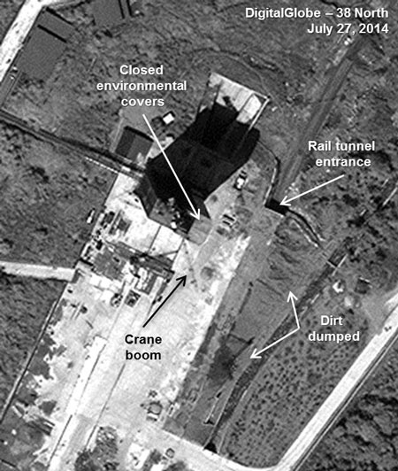
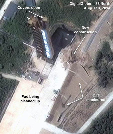
Note: image rotated. Image © 2014 DigitalGlobe, Inc. All rights reserved. For media licensing options, please contact [email protected].
Work on a rail spur leading to the launch pad—expected to deliver rocket stages directly to the pad—appears finished, although construction continues where the spur exits a tunnel at the east end of the pad. The exact route of the spur remains unclear. It may continue on the old road and then switch onto the pad or terminate 40 meters past the tunnel exit. Imagery from August 8 indicates that 8 meter and 10 meter beams seen 10 days earlier, similar to those used to cover the tunnel, are no longer present, indicating construction has continued.
Heavy rains in mid-July may have caused mud to flow onto the end of the pad and slowed construction, but the area had been partially cleared by August 8. In addition, the stream that runs along side the pad has been rerouted and lined to prevent flooding (figure 2).
Figure 2. Work has progressed on the new rail spur to the launch pad.
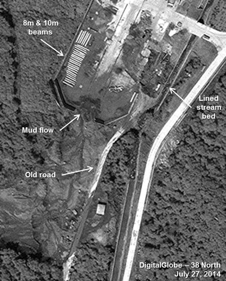
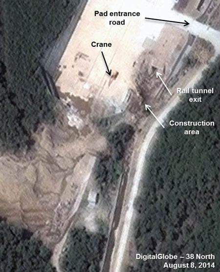
Note: image rotated. Image © 2014 DigitalGlobe, Inc. All rights reserved. For media licensing options, please contact [email protected].
KN-08 Engine Tests Winding Down?
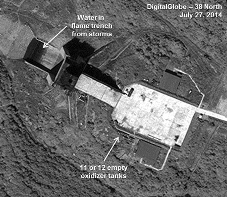
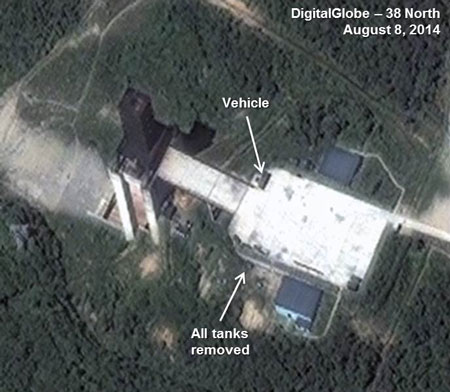
While no imagery was available between early and late July, there are indications that tests of KN-08 road-mobile intercontinental ballistic missile (ICBM) engines took place last month before heavy rains began in mid-July. Imagery in early July showed a KN-08 first stage just off the engine test stand pad as well as 2-4 small oxidizer tanks used for rocket fuel near the storage building. On July 27, 11-12 small tanks can be seen near this building. Water is visible in the flame trench, probably from heavy rain, and the road to the pad has been damaged. By August 8, the road appears to have been repaired and all the tanks that were probably empty had been removed. There was also little activity on the test pad itself (figure 3).
Figure 3. Tanks have been removed from the engine test stand.
Note: image rotated. Image © 2014 DigitalGlobe, Inc. All rights reserved. For media licensing options, please contact [email protected].
Facility Construction Nearing Completion
Recent commercial satellite imagery indicates work appears to have been completed on a number of projects around the Sohae test facility, including: 1) three facilities located near each other where construction began in mid-2013; 2) a new buried cable communications system installed over the past month; and 3) demolition of older buildings including the motor pool. These projects may represent another phase in an active, ongoing effort to upgrade this site.
1. High Priority Construction of Domed Buildings and a Pad
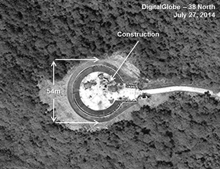
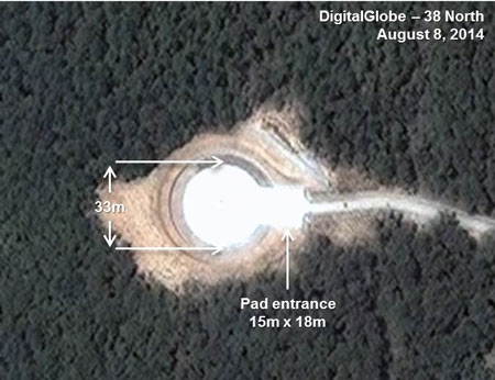
Located in the northeast section of the Sohae test facility, this complex has been the focus of construction efforts since mid-2014. Initially, priority was placed on construction of two new domed buildings, but over the past month, efforts have shifted to a new project nearby with work on what appears to be a circular pad. Groundbreaking at this area began mid-2013 but was never completed. Work continued until early 2014 when the focus of construction efforts shifted to the domed buildings 160 meters to the northeast.
With construction essentially complete at the domed structures by early July, work resumed at this other site which was leveled into a 50-60 meter in diameter circular area and the road leading to it was widened to 4 meters. By late July (in the span of three weeks), the pad—consisting of a white concrete pad 33 meters in diameter surrounded by what appear to be two circular roads, each five meters wide—was nearly finished. The entrance onto the pad is 15 meters wide and 18 meters long. By August 8, construction was complete (figure 4).
The exact purpose of this new circular pad remains unclear. It may be located too close to the new domed buildings—the larger one only 160 meters away—to be safely used to launch missiles. However, because of the launch azimuth to the south, missiles would not overfly populated areas in North Korea. Alternatively, the pad could be used for training mobile missile units or demonstrations of missile systems to prospective foreign clients. Another possibility is the pad may be used for helicopters carrying VIPs visiting the site and the domed buildings nearby.
Figure 4. New possible mobile missile related pad.
Note: image rotated. Image © 2014 DigitalGlobe, Inc. All rights reserved. For media licensing options, please contact [email protected].
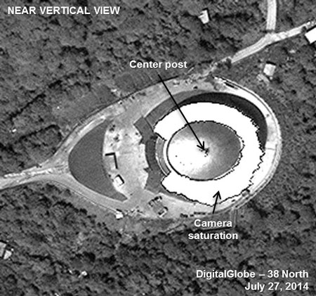
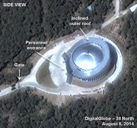
Imagery from August 8 indicates that the larger circular building with a 30 meter dome, under construction since spring 2014, is externally complete and painted light blue. Activity seen around the building in late July has ended. Eight construction sheds located in the trees alongside the road to the building have been removed. A temporary gate has been set up at the access road and four vehicles are seen stopped on the road (figure 5).[1]
Figure 5. The larger domed building appears externally complete.
Note: image rotated. Image © 2014 DigitalGlobe, Inc. All rights reserved. For media licensing options, please contact [email protected].
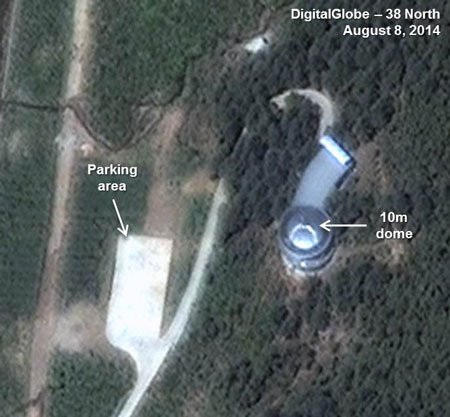
Imagery indicates that the nearby two-story 18 meter circular building that mounts a 10 meter dome is now also externally complete and also painted light blue.
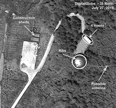
Attached to the circular building is a curved 28 meter building with four masts at its end that may be flags. A parking area for vehicles possibly intended to transport personnel or visitors is connected by a paved road to the curved building (figure 6).
The role of these three associated installations is still uncertain. As noted in 38 North’s last analysis, the internal layout of the larger structure indicates that it may be an auditorium intended for use as a training center; an area for displaying SLV/missile hardware; a launch control center that might accommodate VIPs, clients or the media; or even a center for high-level meetings related to the rocket program.
Imagery from July 27 provides further information on the function of the smaller building, probably ruling out any role in the radar tracking of launches and reinforcing the possibility that it is a check-in, orientation or media center. The presence of twenty ribs under the fabric holding the dome in place indicates that a tracking antenna would not be located underneath, since the ribs would adversely affect its accuracy.
Figure 6. The smaller domed building nearby also appears externally complete.
Note: image rotated. Image © 2014 DigitalGlobe, Inc. All rights reserved. For media licensing options, please contact [email protected].
2. New Buried Cable Communication Network Rapidly Installed
Recent commercial satellite imagery indicates the North Koreans are installing a new, second buried communications cable. The purpose is to link the Sohae facilities into a high-speed communications system as well as to improve links with Pyongyang. The new network may also be necessary because of the increased instrumentation requirements for a large new SLV. Imagery from July 27 shows the excavation of trenches that were completed and covered by August 8.
While the exact extent of the network remains unclear since parts of it may have been installed adjacent to several roads under construction, the missile assembly building seems to be the switching center, probably because of its geographic location at the center of the test range. The network currently connects: 1) the launch control center and the two VIP hotels in the east; 2) the 10 meter dome building in the northwest; and 3) the Unha launch pad as well as the new barracks and vehicle storage area in the south. The connection to the hotels may be used to facilitate VIP voice and text communications.
There is no evidence that the network is connected to the large new domed building or pad although it is possible cable was installed adjacent to the new road to these facilities when it was built in mid-2013. Moreover, there is no evidence yet that the network is connected to the engine test stand or launch instrumentation site. (There may be a cable trench to the observation site in the same area but it remains unclear.)
3. Old Buildings Quickly Demolished
While new construction appears to be nearing completion, orders seem to have been given to clean up the facility by demolishing the old motor pool buildings and a newer two-story building across the road from the rail station. A similar cleanup effort was undertaken when three military facilities were demolished prior to the media visit in advance of the April 2012 Unha-3 launch. The motor pool compound was used extensively for the April and December 2013 launches, particularly as the location for trailers that moved the Unha-3’s first and second stages from the train into the assembly building and then down to the launch pad. Since the open space and road leading to it remains and a new motor pool has not been identified, it is possible the North Koreans will still use this area for parking rocket stage trailers (figure 7).
Figure 7. Old buildings at the motor pool have been demolished.
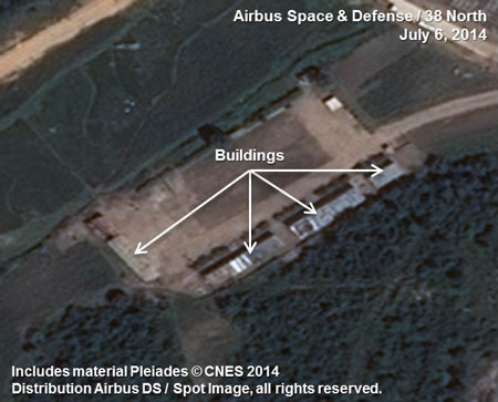
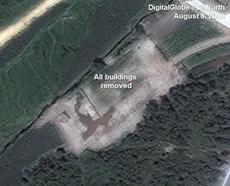
Note: image rotated. Image before includes material Pleiades © CNES 2014. Distribution Airbus DS / Spot Image, all rights reserved. Image after © 2014 DigitalGlobe, Inc. All rights reserved. For media licensing options, please contact [email protected].
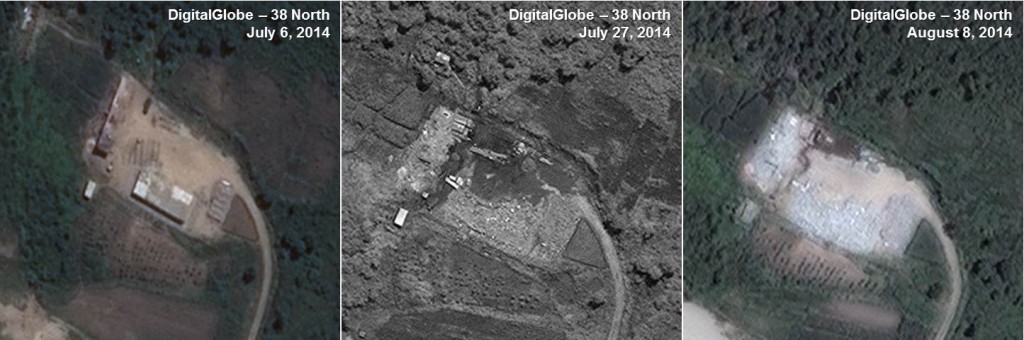
The second demolished facility is relatively new, built quickly before the April 2012 Unha-3 launch. Shortly after the test, probable empty fuel tanks were seen here, possibly in storage until they could be returned by rail to the producer. Probable fuel tanks have never been seen here again. An April 2012 ground photo of the building indicates it may be a guesthouse or barracks, with several smaller support buildings. The structure may have been built for the influx of engineers needed for the Unha-3 launches. Throughout 2013 and into 2014 low levels of activity (usually one or two vehicles around the building) were seen here (figure 8).
Figure 8. A building across from the rail station has been demolished.
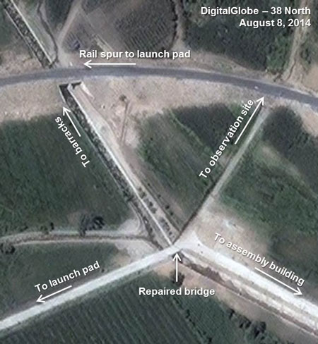
Mid-July Flood Damage
Torrential rains in mid-July hit North Pyongan Province and by July 17, had caused major flooding and destruction of homes and crops throughout the area. The flooding continued through at least July 22 and KCNA reported the floods had caused 13 deaths and damaged thousands of homes. Located in this province, the Sohae facility also incurred some damage that must have delayed some construction for at least a week. The most serious was the undermining of the road bridge that connects the main part of the complex with the launch pad, the engine test stand and the instrumentation site. When seen on July 27, repairs were being made to the bridge and by August 8 it was finished (figure 9).
Figure 9. Flood damaged areas repaired by early August. (Note: trenches seen for communications cabling.)
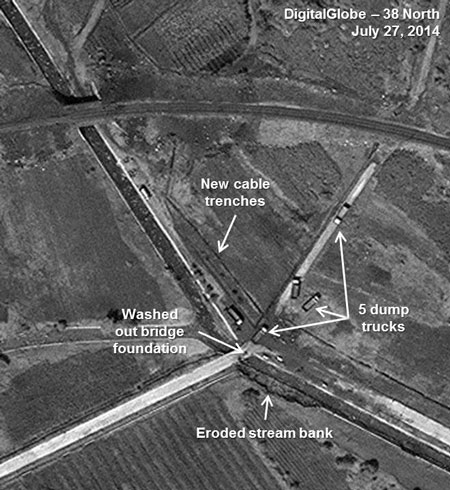
Note: image rotated. Image © 2014 DigitalGlobe, Inc. All rights reserved. For media licensing options, please contact [email protected].
[1]Metadata for the August 8, 2014 image is critical to determining the building’s dimensions and why the glare off the dome is so intense. The image was taken at 39 degrees off nadir (51 degrees to the Quickbird-2 satellite) and at an azimuth of 260 degrees to the target (80 degrees to the satellite). The elevation angle to the sun is 55.6 degrees and the derived azimuth from the sun to the building is about 290 degrees. As shown, the outer circular roof ring is inclined from about the first floor on the south side to over the third floor at the north end of the building. (The July 4, 2014 image previously featured had shown the north end of the building.) The dome is level in the center and attached at the top of the second floor. The building is about 45 meters in diameter and assuming a rise of about 18 meters from the first floor to the roof. The roof therefore is inclined to the north at about 22 degrees. The glare from the dome is caused by the reflective material of the roof, probably Mylar, and the close relationship of the sun angles and the angles to the satellite. The satellite sees the intense glare because it is positioned close to the angles to the sun, and it nearly saturates the camera.